Bar chart showing percentage of residents that feel informed about AI for rural Nebraska and statewide

Nebraska Rural Poll Interactive Report

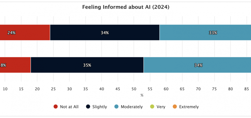
This interactive report visualizes data collected by the annual Nebraska Rural Poll–the longest-running poll of rural life in the United States. The data spans topics including artificial intelligence, access to health care and natural resources, community, government policy, well-being, and more.

Missouri Department of Health and Senior Services Health Data portal

Missouri Health Data

This data portal provides access to results from the 2016 and 2022 Missouri County-Level Studies (CLS) and the Behavioral Risk Factor Surveillance System (BRFSS) data from 2014-2024. Data can be accessed through the reporting interface and the Map Room.

The Ardmore Institute for Health logo. A colorful sunbeam logo with the words "Ardmore Institute for Health - Full Plate Living"

Ardmore Institute for Health

In partnership with the Johns Hopkins Bloomberg School of Public Health, CARES is working with the Ardmore Institute for Health to examine the impact of Blue Zones and Wellville initiatives on communities across the United States. Using longitudinal data to assess health interventions and outcomes, the final report will provide insight into the efficacy of certain health interventions and strategies.

Civic Muscle Index logo

Civic Muscle Index

The Civic Muscle Index assesses belonging, contribution, leadership, and vitality characteristics for counties across Missouri and the city of St. Louis. These indicators are indicative of communities where residents thrive, economies prosper, and neighborhoods flourish. The tool also features a peer counties report, allowing comparison between the Civic Muscle of like counties.

Rural Opioid Response Hub logo

Rural Opioid Response (ROR)

The Rural Opioid Response Program (RCORP) Hub, or Opioid Hub, was developed to help communities analyze and disseminate data and outcomes on opioid issues in rural communities. The tools and data from the Opioid Hub are now available on the Missouri Recovery Friendly Workplaces site.

The Wellness Wheel results showing scores for each category.

UNH Extension Wellness Wheel

The Wellness Wheel assessment was developed by University of New Hampshire Extension and web-enabled by CARES. The Wellness Wheel assesses an individual’s perception of overall wellness and aims to improve overall quality of life and healthy habits through personal decision-making. Additional information about the Wellness Wheel is available at: https://extension.unh.edu/health-well-being/programs/wellness-wheel-assessment

The winmeasure.org site. A field of windmills sits behind text that says, "Well Being in the Nation"

WINMeasures.org

CARES provides data, visualizations, and web hosting services to WINMeasures.org. Supported by the Well-Being in the Nation (WIN) Network, WINMeasures.org provides data on the Well-being of People, Well-being of Places, and Equity. Leading indicators are searchable at the national, state, county, and city level (where available) and encompass a core set of equity-focused social determinants.

The NC Data Portal homepage. It features green fields and text that reads, "Visualize Health Across North Carolina."

North Carolina Data Portal

The North Carolina Data Portal provides data, maps, and tools to support community health assessments and other public health activities in North Carolina. The Hub includes data from both national secondary sources and the North Carolina Department of Health and Human Services. Data are available at state, county, and health department region levels.

The homepage of SparkMap

SparkMap

CARES launched SparkMap in 2019. SparkMap hosts a robust Community Needs Assessment tool, data upload tools, ZIP code level reports, and more. SparkMap is a great subscription service for healthcare consultants, grant writers, community benefit managers, and others working on community needs assessments.

The ParkServe map of the United States showing parks across the country.

Trust for Public Land

CARES provided data analysis and programming support for the ParkScore and ParkServe projects created by the Trust for Public Land. ParkServe is the country’s most comprehensive parks database for over 15,000 urban cities and towns across the country. The ParkScore® index is the national gold-standard comparison of park systems across the 100 most populous cities in the United States.