Map of Missouri House District 6

Missouri State and House District Maps

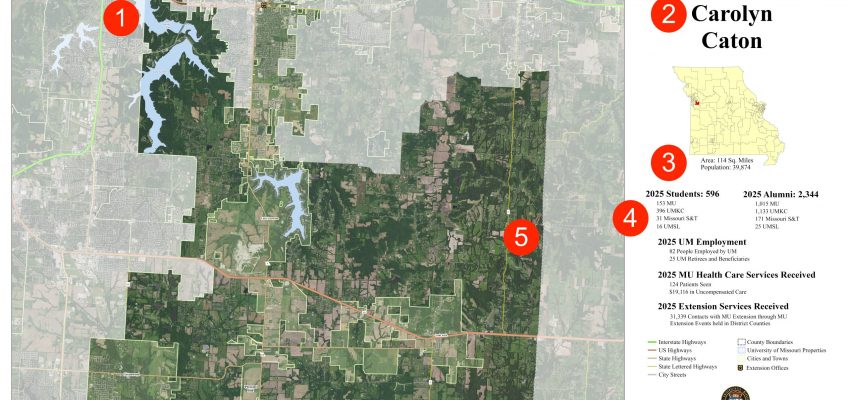
Missouri District Maps are the perfect addition to any city hall, county courthouse, district office, or legislative office. They are produced using high resolution base maps and include county and city boundaries; area and population statistics; and UM System enrollment, alumni, employment, health services, and Extension services. The maps and data are updated annually.

A screenshot of the homepage of the Stone and Taney Counties Data Dashboard.

Stone and Taney Counties Data Dashboard

The Stone & Taney Counties Data Dashboard is a regional gateway to data on key issues affecting local communities. Local organizations use the dashboard to find data for the following categories: housing and families, childcare, transportation, food environment, digital equity, education, jobs, and health.

Mogul 8-16 Titan tractor in field

American Tractor Club

The American Tractor Club is committed to preserving the history of iconic tractors across the country. The online repository is a first of its kind where tractor enthusiasts can upload images, videos, and stories about their historic machines.

The winmeasure.org site. A field of windmills sits behind text that says, "Well Being in the Nation"

WINMeasures.org

CARES provides data, visualizations, and web hosting services to WINMeasures.org. Supported by the Well-Being in the Nation (WIN) Network, WINMeasures.org provides data on the Well-being of People, Well-being of Places, and Equity. Leading indicators are searchable at the national, state, county, and city level (where available) and encompass a core set of equity-focused social determinants.

The ParkServe map of the United States showing parks across the country.

Trust for Public Land

CARES provided data analysis and programming support for the ParkScore and ParkServe projects created by the Trust for Public Land. ParkServe is the country’s most comprehensive parks database for over 15,000 urban cities and towns across the country. The ParkScore® index is the national gold-standard comparison of park systems across the 100 most populous cities in the United States.

Illinois Association of Community Action Agencies logo

IACAA Data Hub

CARES provides widgets to the Illinois Association of Community Action Agencies to assist local Community Action Agency staff in the development of Community Needs Assessments (CNAs). IACAA hosts CARES Data Tools on the IACAA organizational website. CARES provides access to core indicators for assessing and addressing poverty.

Building Regional Resilience logo

Building Regional Resilience

The Building Regional Resilience Hub was active between 2018 and 2024 and provided counties across the nation with a resilience index and underlying data to support the creation and enactment of community resilience plans.

Coalition Against Trafficking and Exploitation logo

Coalition Against Trafficking & Exploitation

CARES partners with the Coalition Against Trafficking and Exploitation (CATE) to maintain an interactive and dynamic resource map. The resource map is embedded on the CATE website and updated annually with new information.

Community Action Partnership logo

Washington State Community Action Partnership

The Washington State Community Action Partnership Data Hub is designed to assist local Community Action Agency staff in the development of Community Needs Assessments (CNAs). The WSCAP Data Hub provides access to core secondary indicators for assessing and addressing poverty. The Hub also provides Washington CAA’s with access to county-level COVID-19 data.

Missouri Community Action Network logo

Missouri Community Action Network

The Missouri Community Action Network Data Hub is designed to assist local Community Action Agency staff in the development of Community Needs Assessments (CNAs). Launched in the early 2000’s, Missouri CAN was our first Community Needs Assessment report. The Missouri CAN Data Hub provides access to core secondary indicators for assessing and addressing poverty. The Hub also provides Missouri CAA’s with access to state-sourced data and a full Map Room.